Чувал съм, че имало, знам, че я изработил Сталин и че е в Сибир. Гледал съм атласи, ама нещо не ми известна...може ли да ми дадете инфо за нея.
-

THE LABARUM

sevot yhtils eht dna ,gillirb sawT`
ebaw eht ni elbmig dna eryg diD
,sevogorob eht erew ysmim llA
.ebargtuo shtar emom eht dnA
Бе сгладне и честлинните комбурси
тарляха се и сврецваха във плите;
съвсем окласни бяха тук щурпите
и отма равапсатваха прасурси. -
Как бе ...със столица Биробиджан - някъде покрай Амур ако не се лъжа.
Татари, Германци, Евреи, Таджики, Гърци, Чеченци ...ей така на прима виста се сещам за преселването на тези народи, а ако се задълбоча малко и направя по-серизоно проучване...колко ли още ще се окажат че са размотавани насам натам из Средна Азия и Сибир. Много хуманна методика за оползотворяване на територията на СССР - няма що! -
Имат си даже и сайт : http://www.eao.ru
Ето тук за историята им: http://www.eao.ru/?p=45
Тука на столицата им сайта:

Мерси, че ми даде името, Албирео!
THE LABARUM
sevot yhtils eht dna ,gillirb sawT`
ebaw eht ni elbmig dna eryg diD
,sevogorob eht erew ysmim llA
.ebargtuo shtar emom eht dnA
Бе сгладне и честлинните комбурси
тарляха се и сврецваха във плите;
съвсем окласни бяха тук щурпите
и отма равапсатваха прасурси.Comment
-
ето от страницата на "Комерсант"
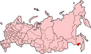
Jewish Autonomous Region
// GENERAL INFORMATION
The Jewish Autonomous Region is located in the Trans-Amur (Priamurye) territory of the Russian Far East. It has an area of 36 300 km2 (0.21% of the Russian Federation). The region borders on China in the south and west, Amur Region in the northwest, and Khabarovsk Territory in the north, northeast, and east. The Amur River connects the region to the Pacific Ocean. Other rivers belonging to the Amur basin have a total length of 8231 km and include the Bira, Bidzhan, Birakan, In, Urmi, and Ikura. The Trans-Siberian Railway passes through the region, connecting it with Western Europe, Middle East, and countries of the Asia-Pacific region.
Emblem
The Jewish Autonomous Region has a temperate monsoon climate. Average winter temperatures range from -21 to -26 °C with relatively little snow. Summers are warm and humid with average temperatures from +18 to +21 °C. Annual precipitation ranges from 500 to 800 mm, falling mainly in summer.
Soils are typically brown forest, meadow-swampy, and alluvial. Both coniferous (spruce, fir, and cedar) and mixed (larch, oak, and birch) forests are widespread. The soil and climatic conditions are favorable for agriculture.
Flag
The region's plant and animal life is abundant and varied. More than 200 honey-producing plants and nearly 300 medicinal plant species, including the rare bracken fern, are found here, and the forests abound in berries, mushrooms, and nuts. Wildlife includes 59 species of mammals, such as brown and Himalayan bears, yellow-throated marten, foxes, mink, sable, wild boar, moose, and Manchurian elk. Pheasants and various kinds of ducks are among the birds encountered here. The rivers and other water bodies are the habitat of 73 species of fish, including various species of carp, Amur sturgeon, Siberian salmon, Manchurian trout, Amur bream, Russian sturgeon, sazan [a member of the carp family], burbot, taimen [a large member of the salmon family], grayling, and pike. There are five state nature reserves in the region.
The Jewish Autonomous Region has some of Russia's richest reserves of economic minerals, with large deposits of iron, manganese, tin, gold, graphite, brucite, magnesite, zeolites, coal, oil, gas, various building materials, and other minerals. The region also has medicinal mineral springs.
Birbobidzhan, with a population of about 84 000, is the administrative, economic, and cultural center of the Jewish Autonomous Region.
HISTORY
The early inhabitants of the Priamurye region were isolated tribes of Daurs, Duchers, and Tungus. Then in 1644, the tsar sent an expedition led by Vasily Poryakov to explore the Priamurye lands. Following the expedition, fugitive Cossacks, free industrialists, peasants, and religious dissenters (raskolniki) gradually arrived to settle the rich lands. By the latter half of the 19th century, there were 63 population centers in the territory of the present-day region, including Radde, Pashkovo, Pompeevka, Puzino, Ekaterino-Nikolskoe, Mikhailo-Semenovskoe, and Voskresenovka. Construction of a railway line from Chita to Vladivostok in 1898 brought large numbers of new settlers, who founded new communities like Volochaevka, Obluchye, Bira, Birakan, Londoko, In, and Tikhonkaya. The main occupation of the local population was farming, with the exception of those who worked in the Tunguska timber mill and small railway workshops and mined gold in the Sutara basin. The region was the scene of heavy fighting during the Civil War [1918-1921], and its economy was totally destroyed.
After exploring the southern Priamurye, the government recommended the territory near the Bira and Bidzhan rivers for Jewish colonization. On March 26, 1928, the Presidium of the USSR Central Executive Committee (TsIK) officially assigned these lands to the Jewish people. Birobidzhansky (National) District, with its center in the village of Tikhonkaya, was subsequently formed in 1930. Four years later, it received the status of the Jewish Autonomous Region. The Second World War, which brought so much grief and disaster to the entire Soviet Union, touched the Jewish people as well. More than 11 000 of the region's residents went off to the war and only 4000 returned. In honor of the valor and courage of the Jewish soldiers, the government awarded orders and medals of the USSR to more than 7000 people. Altogether, the Jewish Autonomous Region sent 38 carloads of medical supplies, 1500 carloads of ammunition, 57 trainloads of special packing for ammunition, 48 military transport trains, and 500 000 complete military kits to the front.
Today, the region is a constitutional subject of the Russian Federation. Its status as a free economic zone opens up many possibilities. The region is divided into 59 urban and rural communities, 5 districts and 2 cities (Birobidzhan and Obluchye) and has a population of about 210 000.
RESOURCES
The Jewish Autonomous Region is a rare and unique part of Russia that combines abundant natural, land, and subsurface resources and favorable climatic conditions. It is located in the southern part of the Far East and borders on Amur Region, Khabarovsk Territory, and China. Mountains extending north-northwest occupy half of the region's territory. The southern and eastern parts of the region are in the Middle Amur Lowlands. The soil is very fertile, which is important for agriculture. Forests, which grow mainly in the mountains, cover nearly 40% of the region (2 286 000 hectares). Twenty-six large and 1146 small rivers, all belonging to the Amur basin, flow through the region. The Amur is the main river; it flows for 584 km through the region, reaching a width of 2.5 km at the eastern boundary.
The region's mineral wealth includes the rich Khinganskoe, Karadubskoe, Bidzhanskoe, and Yuzhno-Khinganskoe tin deposits, which also contain silver, molybdenum, gold, copper, lead, zinc, arsenic, bismuth, and antimony. Gold is produced in Maly Khingan and the Sutara River basin. Two rare metal deposits (Preobrazhenovskoe and Diturskoe) and 11 magensite deposits have also been discovered. Brucite is found in four deposits (Kuldurskoe, Tsentralnoe, Savkinskoe, and Taragaiskoe), which contain the world's second largest reserves of this mineral. A talc deposit has been discovered near the town of Birakan. Graphite reserves in the Soyuznenskoe deposit are the world's largest. There are abundant reserves of coal in the Ushumunskoe (brown coal) and Birskoe (hard coal) deposits. In addition, there are 55 peat deposits and 114 deposits of building materials such as clay, clay aggregate, sand, gravel, cement, and facing stone.
ECONOMY
The Jewish Autonomous Region is part of the Far Eastern economic district; it has well-developed industry and agriculture and a dense transportation network. Its status as a free economic zone increases the opportunities for economic development. The region's rich mineral and building and finishing material resources are in great demand on the Russian market. Nonferrous metallurgy, engineering, metalworking, and the building material, forest, woodworking, light, and food industries are the most highly developed industrial sectors. More than 3038 companies and organizations of all economic sectors operate in the region.
Agriculture is the Jewish Autonomous Region's main economic sector owing to fertile soils and a moist climate. A total of 391 100 hectares of land are used for agriculture; this figure includes 136 100 hectares of cropland, 129 900 hectares of hayfields, 104 600 hectares of pasture, and 20 400 hectares of fallow land. There are also sizable areas of vacant land. Plant cultivation is the most developed agricultural sector. The main crops (70% of production) are corn, buckwheat, soybeans, and melons, followed by vegetables (30% of production). Cattle, pigs, and poultry are raised on the rich grasslands, and an abundance of nectar-producing plants creates favorable conditions for beekeeping. More than 700 farms occupying a total of 193 000 hectares of land operate in the region.
The Trans-Siberian Railway runs through the Jewish Autonomous Region, connecting it with Western Europe, the Middle East, and the Asia-Pacific region. In addition, the navigable Amur River, which flows into the Sea of Japan, provides a water route to China, the region's main foreign partner. More than 100 companies are involved in foreign trade; exported products include fertilizer, fish and fish products, oil and petroleum products, timber, and nonferrous metals. Commodity exchange has been established with countries of the Asia-Pacific region, and the region also maintains foreign economic and cultural ties with Israel, the United States, and many other countries.
Local branches of the Central Bank of Russia, Sberbank of Russia, and Khabarovsk-based Regiobank and Dalcombank operate in the region.
The region's well-developed transportation network consists of 530 km of railways, including the Trans-Siberian Railway; 600 km of waterways along the Amur and Tunguska rivers; and 1900 km of roads, including 1600 km of paved roads. The most important road is the Khabarovsk-Birobidzhan-Obluchye-Amur Region highway with ferry service across the Amur. The Zhelty Yar airport located in the center of the region connects Birobidzhan with Khabarovsk and outlying district centers. There are also plans to establish international air service between Birobidzhan and Jiamusi (China).
AUTHORITIES
The Jewish Autonomous Region, formed by a decree signed on May 7, 1934, is part of Khabarovsk Territory. The region is a constitutional subject of the Russian Federation with the legal right to manage the property within its territory.
The region is divided into five districts (Oktyabrsky, Leninsky, Obluchensky, Birobidzhansky, and Smidovichsky), 1 city under regional jurisdiction, 1 city under district jurisdiction (Obluchye), 12 towns, and 47 rural administrations. The capital is Birobidzhan, founded in 1937.
The highest executive body in the Jewish Autonomous Region is the government headed by Governor, who is responsible for forming it. The government has the right to draw up and implement the budget. Regional property and economic structures are also under its jurisdiction.
The highest legislative body in the Jewish Autonomous Region is the Legislative Assembly consisting of 15 people's deputies elected for a two-year term. The Legislative Assembly has the right to review and approve the regional budget; impose or abolish regional taxes; and collect duties, fees, and other payments and determine the procedure for collecting them. It is also responsible for determining ownership and use of land and subsurface and other natural resources in conformity with federal legislation. The regional legislative authorities have the right to introduce laws and amendments in the State Duma of the Federal Assembly of the Russian Federation. The local government bodies in Birobidzhan and the districts consist of city and district assemblies of people's deputies led by the heads of the respective administrations.
Official site of the Administration of the Jewish Autonomous Region:
По моя преценка съм обективен.Comment
-
Така като гледам картата, май доста си падат по бирата тия руски евреи
(\_/)
(°_°)
(> <) <- This is Bunny. Copy Bunny into your signature to help him on his way to world domination.Comment
-
Отначало си помислих, че БИРА е от тюркското вълк, но не, оказва се, че БИРА било река на тунгуски. Но съчетанието Биро-фельд направо ме уби, сигурно е единствената тунгуско-немска, т.е. идиш дума. Beerfeld сигурно звучи като музика в ушите на всеки немец :lol:Warlord написаComment

Comment